Hiking
Mission Trails Regional Park
The part encompasses 7,220 acres of both natural and developed recreational areas. Its rugged hills, valleys and open areas represent a San Diego prior to the landing of Cabrillo in San Diego Bay in 1542. Centrally located and only eight miles northeast of downtown San Diego, Mission Trails Regional Park provides a quick, natural escape from the urban hustle and bustle. Mission Trails Regional Park has been called the third Jewel in the City of San Diego Park System. Along with Balboa Park and Mission Bay Park, it provides San Diego residents and visitors a way to explore the cultural, historical, and recreational aspects of San Diego.
Los Peñasquitos Canyon Preserve
Los Peñasquitos (meaning little cliffs) Canyon Preserve lies between Rancho Peñasquitos and Sorrento Hills to the north and Mira Mesa to the south. It stretches approximately 7 miles from the Interstates 5 and 805 merge to just east of Interstate 15. It encompasses some 4,000 acres of both Peñasquitos and Lopez Canyons. The Preserve is jointly owned and administered by the City and County of San Diego. Los Peñasquitos Canyon Preserve attracts people with its natural beauty and abundant natural resources — both today and in the past. Native American history within the Preserve dates back as far as 7,000 years ago.
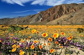
Anza Borrego Desert State Park
Anza-Borrego Desert State Park is a California State Park located within the Colorado Desert of southern California, United States. The park takes its name from 18th century Spanish explorer Juan Bautista de Anza and borrego, a Spanish word for sheep. Anza- Borrego Desert State Park’s rugged landscape formed largely by the forces of erosion attacking the uplifted mountains. The higher the mountains rise, the more vigorously they are attacked by rain, snow, ice, and wind, as they yield to the constant pull of gravity.
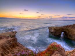
Sunset Cliffs Nature Park
Dedicated in 1983, Sunset Cliffs Natural Park is a 68-acre resource-based park stretching along the Pacific Ocean bordering the western edge of Point Loma. The 18-acre linear section of the park lies to the west of Sunset Cliffs Boulevard between Adair and Ladera streets. The 50-acre hillside section, a designated multiple species conservation area, links to the 640-acre Point Loma Ecological Reserve beginning at the Navy property to the south. The park’s topography includes intricately carved coastal bluffs, arches and sea caves. It affords inspiring panoramic ocean views. From the cliffs, California gray whales often can be seen migrating annually from the Bering Sea to Baja California and back.
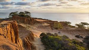
Torrey Pines State Natural Reserve
The Razor Point trail (1.3 miles) or Guy Fleming Trail (0.7 miles) both offer dramatic, picturesque views of the big blue with easy trails accessible to almost anyone. In the winter, you might spot Gray Whales or bottlenose dolphins throughout the year. There’s also a Beach Trail (1.7 miles), which is a bit steeper and allows access to the beach.
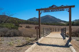
Iron Mountain Trail
Don’t let the name intimidate you. In Poway, this boulder-lined trail is manageable for most hiking levels, making it ultra-popular on weekends. While it begins flat, the climb creeps into the eastern mountains and rewards hikers with panoramic vistas. Pack your sunscreen; little shade is offered. To increase difficulty, additional trails are optional throughout the way to other peaks.